 HB-0069: West D Street - N. Wilkesboro
HB-0069: West D Street - N. Wilkesboro
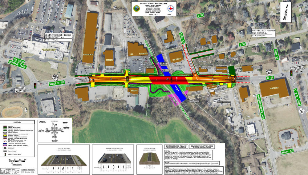
NCDOT proposes to replace the bridge on West D Street (U.S. 421 Business) over the Reddies River in North Wilkesboro, in Wilkes County.
Step 1
Interactive Study Area Map
Project Overview
The bridge, constructed in 1935 and reconstructed in 1967, is considered structurally deficient; Structurally Deficient does not mean that the bridge is unsafe. Structurally Deficient means it is in relatively poor condition or has insufficient load-carrying capacity. The insufficient load capacity could be due to the original design or to deterioration.
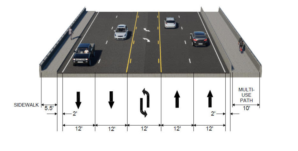
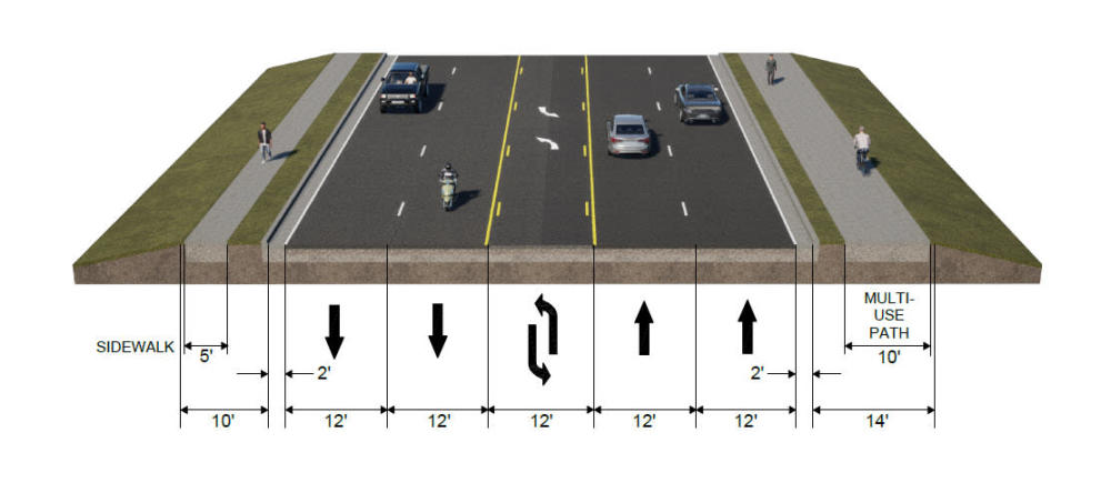
The new bridge will provide two 12-foot travel lanes in each direction, separated by a 12-foot two-way left-turn lane. A 5.5-foot sidewalk is planned for the north side of the new bridge and a 10-foot multi-use path is planned for the south side.
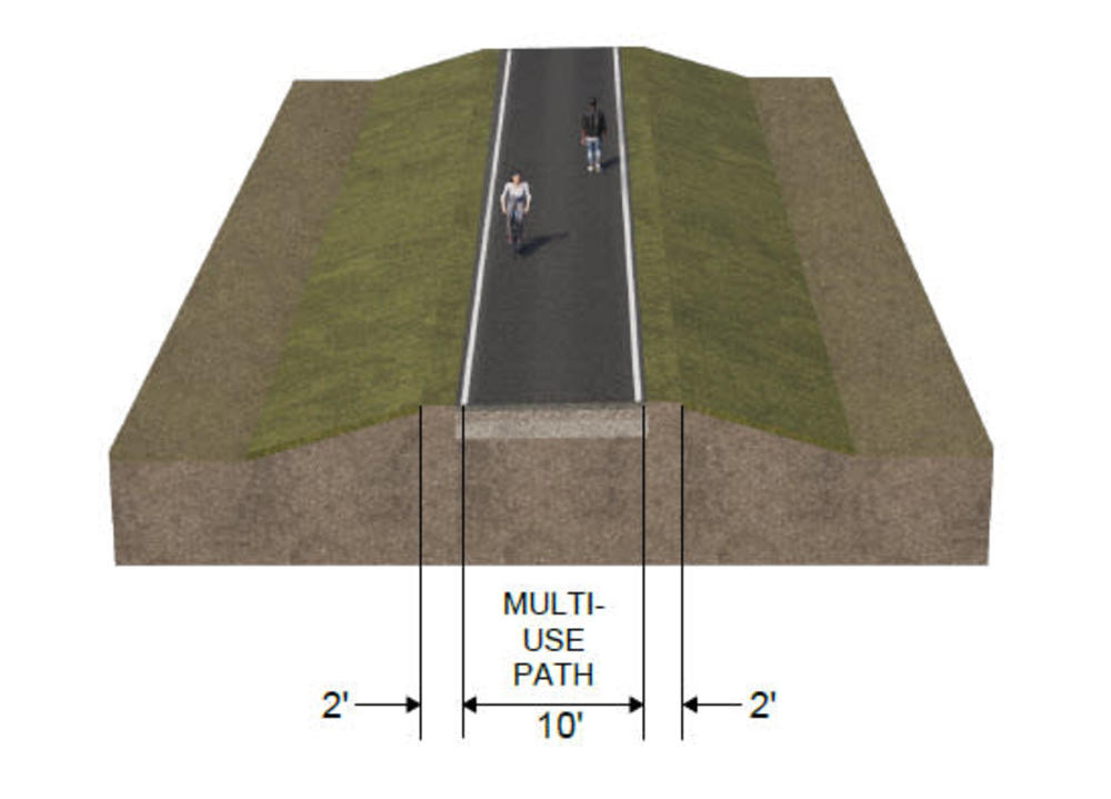
This bridge also crosses the Yadkin River Greenway, which extends along the west side of the Reddies River. A connection from the southwest section of the bridge to the Yadkin River Greenway is planned.
Project Map
Click here or on the map image to open the map in a new window for downloading or viewing.
Typical Sections
Bridge
Approaches to bridge
Greenway
Project Effects to the Yadkin River Greenway
The West D Street bridge crosses over the Yadkin River Greenway, which is located parallel to the Reddies River. This Greenway is afforded certain protections under Section 4(f) of the Department of Transportation Act and is located within an easement owned by the Town of North Wilkesboro.
To ensure compliance with Section 4(f), NCDOT plans to request concurrence with a de minimis 4(f) finding from the Federal Highway Administration and the Town of North Wilkesboro. The term “de minimis” indicates the project will not adversely affect the activities, features, or attributes of the Section 4(f) property.
Actual project effects to the greenway include the following:
Alignment
The existing greenway extends under the West D Street (US 421 Bus.) bridge, continuing north to a trailhead at the parking lot near the Anchor Coffee restaurant.
This greenway section will be slightly realigned to offset it from the new bridge components, including interior bents, and reconstructed earthen berm, as well as a new retaining wall. All existing features/attributes of the greenway will be maintained or replaced as part of this realignment.
Enhancement
The bridge replacement will include two enhancements to the Yadkin River Greenway:
- Pedestrian Accommodations on Bridge
The new bridge will include a 10-foot-wide multi-use path on the south side and a 5.5-foot sidewalk on the north side. This is an enhancement for greenway operations since the greenway access is improved for both bicyclists and pedestrians.
- New Greenway Connector
A new greenway connector will be constructed from the southwest side of the replacement bridge, extending to the existing greenway south of the bridge. The current greenway configuration south of the replacement bridge will be retained and the new connector provides an additional feature that will enhance greenway operations.
Temporary Closure
To ensure safety for greenway users, the greenway section at the West D Street (US 421 Bus.) bridge will be closed during construction of the new bridge and demolition of the current bridge. Temporary closure of this greenway section will last approximately 2-3 years during active construction activities.
Project Funding:
Activity | Estimated Costs* |
Project Development & Design | $ 1.7 Million |
Utilities | $ 0.7 Million |
Right-of-Way | $ 0.8 Million |
Construction | $ 21.1 Million |
Total Cost | $24.3 Million |
*Estimated costs are subject to change.
Project Timeline:
Activity | Anticipated Date* |
Right of Way Acquisition Begins | Fall 2025 |
Construction Begins | December 2026 |
*Future dates subject to change
Project Comments:
NCDOT accepts comments throughout all phases of project development.
All comments will be taken into consideration, and carry equal weight, regardless of submittal method.
Public comments regarding the proposed de minimis 4(f) finding (see above) were due by January 31, 2025.
Thank you for your assistance with the planning and design of this bridge replacement.
The public is encouraged to leave comments using this email or phone number:
Email: DStreetBridge-NWilkesboro@publicinput.com
Phone Number: 984-205-6615 and enter project code 10585
Project Contact Information
Daniel Adams, P.E.
Division Project Team Lead
NCDOT Division 11
801 Statesville Road
North Wilkesboro, NC 28659
Project Contact Information
Sam Cullum, P.E.
Consultant Project Manager
Kisinger Campo & Associates
301 Fayetteville Street, Suite 1500
Raleigh, NC 27601
Title VI Feedback
To ensure we’re hearing from a broad set of voices, would you be willing to share (completely anonymously) some information about yourself?
If so, please click here https://publicinput.com/NCDOT-Title-VI-Form
Resources for Property Owners
Although the N.C. Department of Transportation works to minimize the number of homes and businesses displaced by a road
project, it is inevitable, in many cases, that a certain amount of private property is needed. The following information explains right
of way acquisition and answers questions about the process.
Right-of-Way Brochure Single Page Layout Folleto del Proceso de Adquisición de Bienes Raíces
Right-of-Way Frequently Asked Questions
Right of Way Acquisition Process Videos
Page last updated: May 19, 2026
ADA Compliance Checked