 U-3422: Camden Road Cumberland County
U-3422: Camden Road Cumberland County
NCDOT proposes to make improvements to Camden Road between the Fayetteville Outer Loop and N.C. 59 (Hope Mills Road/N.Main Street) in Cumberland County.
Step 1
Interactive Study Area Map:
General location of project
Project Overview and History
The N.C. Department of Transportation proposes to make improvements to approximately 3.7 miles of existing Camden Road (S.R. 1003) between the future Fayetteville Outer Loop (I-295) to west of N.C. 59 (Hope Mills Road/N. Main Street) in Cumberland County. Camden Road is currently a two-lane roadway that provides access from western Cumberland County to N.C. 95, I-95 Business, and downtown Fayetteville.
This project proposes to make improvements including:
widening the roadway to four-lanes (two in each direction)
adding a raised median
creating Reduced Conflict Intersections
installing U-turn bulbs
The project is divided into two sections A and B as shown in the maps below.
Section A begins adjacent to the I-295 (Fayetteville Outer Loop) offramp and continues eastward to west of Teeters Road
Section B begins just west of Teeters Road and continues eastward to U.S. 59 (Hope Mills Road/N. Main Street).
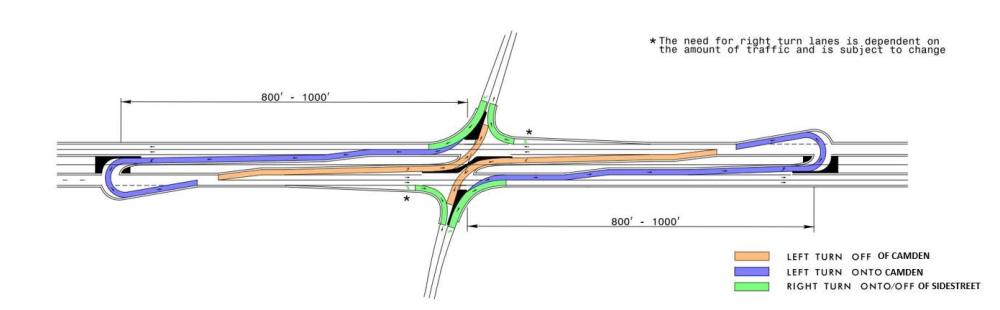
Reduced Conflict Intersections
A Reduced Conflict Intersection – sometimes referred to as a superstreet, a synchronized street, or a median U-turn is a general term used to describe several types of designs that can be used to improve safety and traffic flow on a highway by cutting more than half of the potential locations, or conflict points, where drivers and pedestrians can collide.
The most common type of Reduced Conflict Intersection design eliminates left turns from side roads onto busy main roads. Raised medians direct traffic from the side road into turning right. When there is a safe opening in traffic, drivers enter the flow of traffic on the main route. To go the other direction, or cross the highway, drivers pull into a dedicated lane – typically less than 1,000 feet away – and make a U-turn. There might be a traffic signal at this location.
With a Reduced Conflict Intersection, drivers from the side street only have to be concerned with one direction of traffic on the highway at a time and do not need to wait for a gap in both directions to cross a major road.
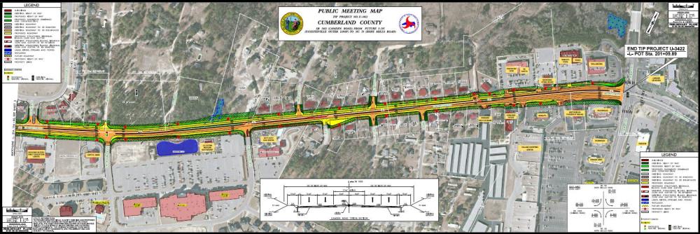
Project Maps and Typical Sections
Clicking on the map(s) below will open them in a new window for viewing or downloading.
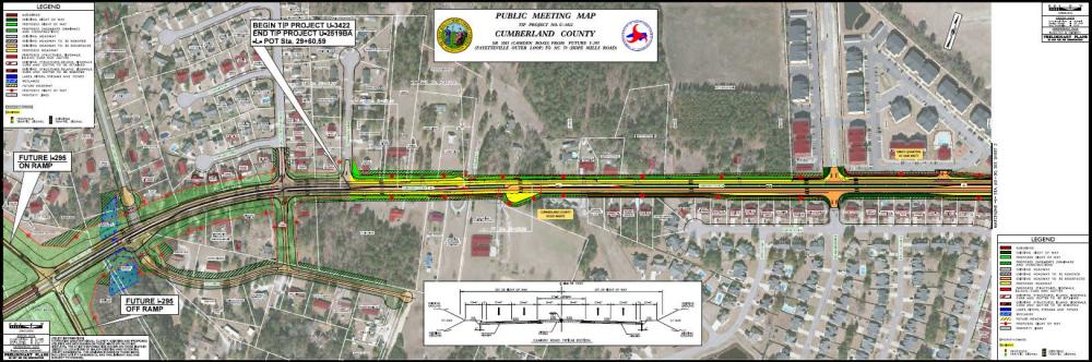
U-3422A
Champs Court (east of I-295 ramps) to West of Teeters Road
Map 1 - Champs Court to West of Waldo's Beach Road
Map 2 - West of Waldo's Beach Road to West of Wipporwill Drive
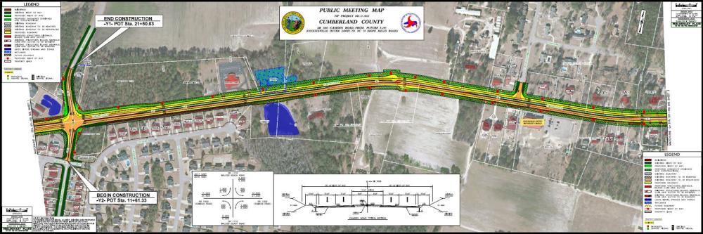
Note that the final portion of U-3422A is shown on Map 3
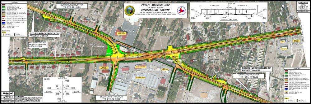
U-3422B
East of Beswick Court to N.C. 59 (Hope Mills Road/N. Main Street)
Map 3 - West of Champs Road to East of Almond Road and includes the Camden Road/Rockfish Road intersection
Map 4 - East of Almond Road (west of Harrisburg Drive) to N.C. 59/N. Main Street in Hope Mills.
Project Funding:
Activity | Estimated Costs (A & B)* |
Project Development and Design | $ 1.600 Million |
Right-of-Way Acquisitions | $ 9.975 Million |
Construction | $ 82.600 Million |
Total Cost | $ 94.175 Million |
*Estimated costs are subject to change.
Project Timeline:
Activity | Date* |
Right-of-Way Acquisition Began | July 2021 |
Section A - Award for Construction | December 2025 |
Section B - Award for Construction | October 2026 |
*Future dates subject to change
Project Comments:
NCDOT accepts comments throughout all phases of project development.
All comments will be taken into consideration, and carry equal weight, regardless of submittal method.
Comments for consideration during the current phase of project development
were to be submitted by November 15, 2024
The public is encouraged to leave comments using this webpage, email, or phone number:
Email: Camden-Road-Cumberland@publicinput.com
Phone Number: 984-205-6615 and enter project code 10860 to leave a message
Project Contact Information
Sean Matuszewski, PE
Division Project Manager
NCDOT Division Highway 6
P.O. Box 1150
Fayetteville, NC 28301
Project Contact Information
Phillip Rogers, PE
Consultant Project Manager
HDR
555 Fayetteville Street, Suite 900
Raleigh, NC 27601
Title VI Feedback
To ensure we’re hearing from a broad set of voices, would you be willing to share (completely anonymously) some information about yourself?
If so, please click here: https://publicinput.com/NCDOT-Title-VI-Form
RESOURCES FOR PROPERTY OWNERS
Although the N.C. Department of Transportation works to minimize the number of homes and businesses displaced by a road
project, it is inevitable, in many cases, that a certain amount of private property is needed. The following information explains right
of way acquisition and answers questions about the process.
Right-of-Way Brochure Single Page Layout Folleto del Proceso de Adquisición de Bienes Raíces
Right-of-Way Frequently Asked Questions
Right of Way Acquisition Process Videos
Page last updated: January 7, 2026