 BR-0192: N.C. 43 BUS / N.C. 48 - Rocky Mount
BR-0192: N.C. 43 BUS / N.C. 48 - Rocky Mount
Replace bridge over the Tar River along N.C. 43 BUS / N.C. 48 (Falls Road) in Rocky Mount, Nash County.
Step 1
Interactive Project Study Area Map
Project Overview
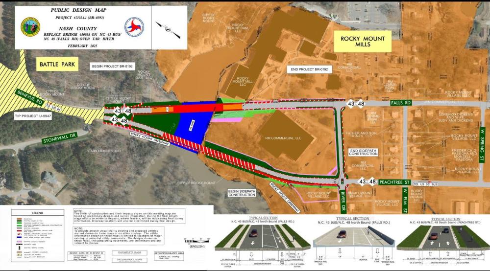
The N.C. Department of Transportation, Highway Division 4, proposes to replace the bridge over the Tar River on N.C. 43 BUS / N.C. 48 (Falls Road) upstream of the Rocky Mount Mills Dam in Rocky Mount. The Falls Road bridge carries one-way traffic northbound while the parallel Peachtree Street bridge carries southbound traffic. The Falls Road bridge will be replaced on the existing alignment. During construction, Falls Road will be closed in the area of the replacement, and an offsite detour will be used. A map of the detour route is shown below.
Project Map
Clicking on the photo below will open it in a new window for downloading or viewing.
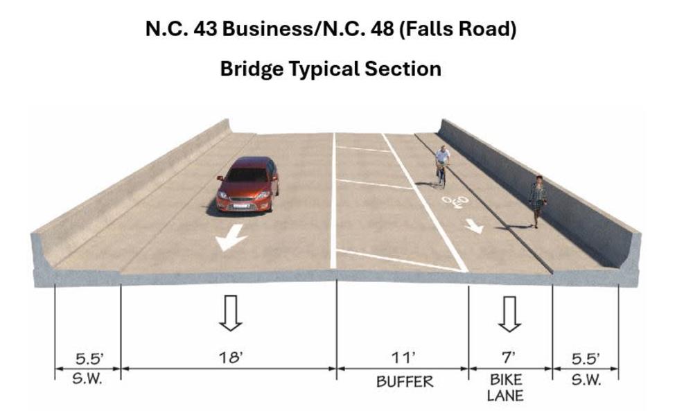
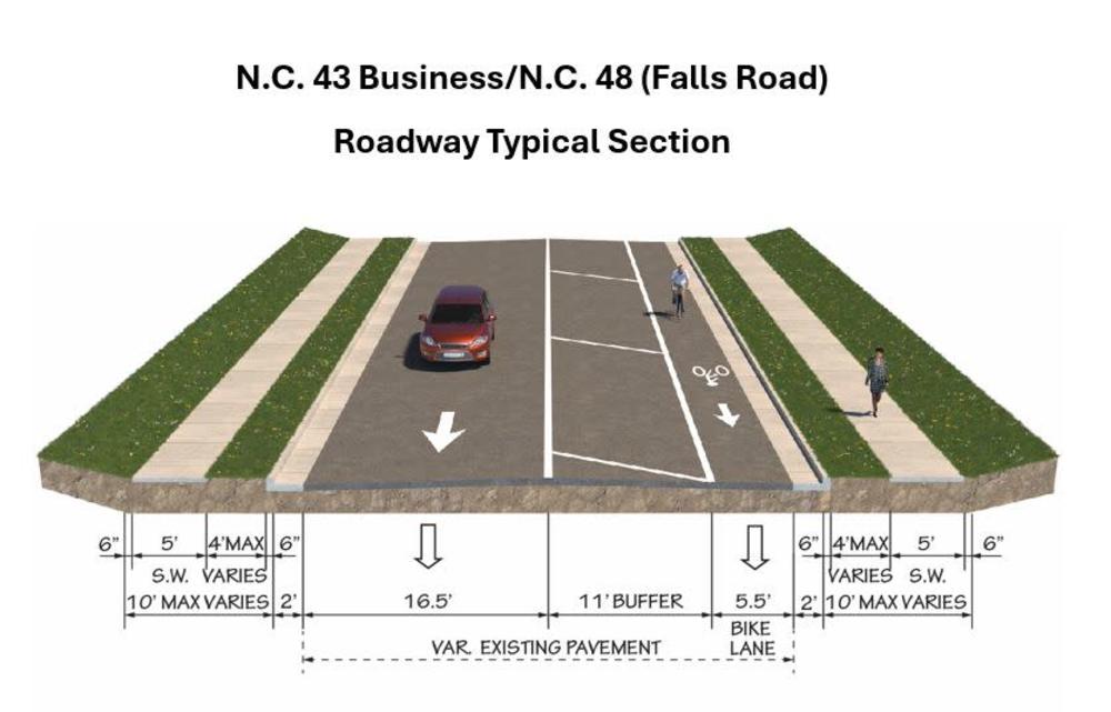
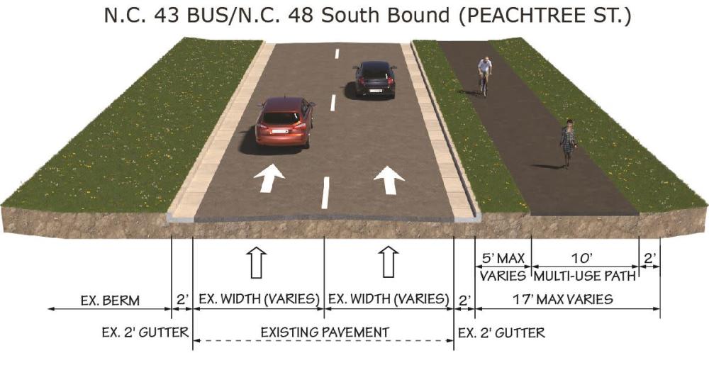
Typical Sections
_______________________________________________________________________________________________________________________________
______________________________________________________________________________________________________________________________
_______________________________________________________________________________________________________________________________
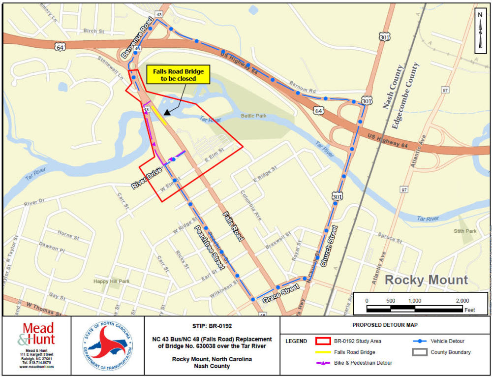
Proposed Detour
To minimize impacts to the environment and expedite construction, the bridge will be replaced on existing alignment. During construction, the Falls Road bridge will be closed, and a detour will be in place for approximately 12-15 months.
Vehicular detour – An offsite 3-mile detour is proposed for vehicular traffic traveling northbound on Falls Road. Southbound traffic will continue as normal across the Peachtree Street bridge. The northbound detour will take approximately 7 minutes to travel from one end of the project to the other.
From the southern end of the bridge (near Rocky Mount Mills), the detour route will continue west along River Drive, turn left on Peachtree Street, turn left on Grace Street, and turn left on U.S. 301 Business (Church Street). Use the on ramp to enter U.S. 64, then use exit 468B to NC 43 (Benvenue Road).
A temporary driveway connection from Peachtree Street to Battle Park is proposed during construction.
Vehicular access to Cotton Warehouse and the northern driveway to Rocky Mount Mills will be temporarily altered due to the proposed detour. Options to ensure these locations are safety accessible during construction are being considered.
Pedestrian and bicycle detour – An offsite 0.4-mile detour is proposed for pedestrian and bicycle traffic which will take approximately 10 minutes.
The Bike and Pedestrian Detour includes the addition of a multiuse path along the west side of Peachtree Street from River Drive to the Tar River Greenway bridge. A permanent multiuse path will be constructed along the west side of Peachtree Street (where there is currently a worn path) which will provide a direct connection to the existing sidewalks and bicycle lanes.
From the southern end of the bridge (near Rocky Mount Mills), the detour route will continue west along River Drive, turn right on Peachtree Street onto the new multiuse path, and continue across the greenway bridge across the Tar River.
Transit detour - The closure of the bridge will temporarily impact Tar River Transit Golden East Route (Route #5) and four bus stops will be temporarily closed, and the bus route will be diverted along the proposed vehicle detour. Para-Transit service will be offered at each of the closed bus stops until the project is complete.
Clicking on the map will enlarge it for easier viewing.
Project Impacts to Recreation and Historic Properties
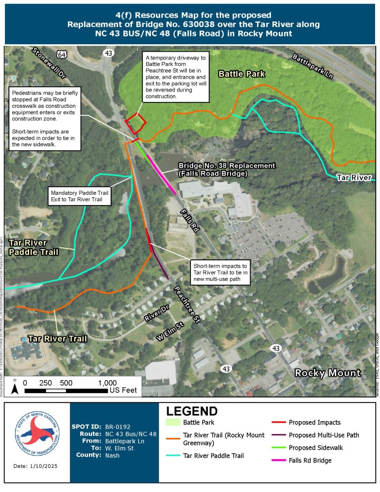
The proposed project has oversight from the U.S. Department of Transportation (USDOT) and is therefore subject to the U. S. Department of Transportation Act of 1966. Section 4(f) of this legislation attempts to protect publicly owned public parks and recreation areas, wildlife and waterfowl refuges, and historic sites from impacts due to transportation project development. NCDOT and the Federal Highway Administration (FHWA) have determined three (3) resources within the project area may be Section 4(f) properties; therefore, all impacts to these resources must be evaluated to ensure they comply with the legislation. Battle Park, Tar River Trail (AKA Rocky Mount Greenway), and the Tar River Paddle Trail are potential 4(f) recreational resources for the City of Rocky Mount. The locations of these recreational and historic resources, and proposed impacts are described below. NCDOT would like to receive any comments regarding these impacts in order to inform the City of any concerns.
Recreation Properties
Battle Park
Battle Park is located to the northeast of the Falls Road bridge.
The Battle Park parking lot can only be accessed from Falls Road and this portion of the roadway will be closed during construction. A temporary driveway from Peachtree Street and reversal of the entrance and exit to this parking lot is proposed while the construction detour is in place.
Tar River Trail
The Tar River Trail runs along the north side of the Tar River east of the bridge (through Battle Park), crosses Falls Road and Peachtree Street north of the bridges and continues along the south side of the Tar River (north of River Drive).
The crosswalk carrying the Tar River Trail across Falls Road is immediately north of the construction area. Pedestrians and bicyclists will have access to the crosswalk, but occasionally construction equipment will need to pass over it.
A portion of the Tar River Trail will have a short-term temporary impact to tie in a new multiuse path along the west side of Peachtree Street.
Short-term temporary impacts will also occur to tie in a new sidewalk along the west side of Falls Road from the bridge to the trail crosswalk over Falls Road.
Tar River Paddle Trail
The Tar River Paddle Trail is comprised of ten canoe and kayak access locations that connect over 55 miles of the Tar River and Stony Creek. Due to the Rocky Mount Mills Dam, there is a mandatory exit river left immediately upstream of the Peachtree Street bridge. The next river access is located downstream of the dam within Battle Park.
The egress between the mandatory exit and the downstream access utilizes the Tar River Trail which will be temporary impacted as described above.
Clicking on the map will enlarge it for easier viewing.
Historic Properties
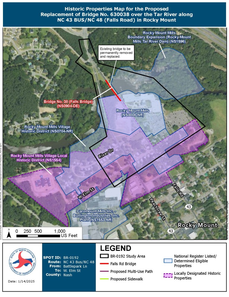
There are five (5) historic properties within the project area. The locations of these historic properties are described below and shown in the “Historic Properties Map”. As project design progresses, effects consultation will occur under Section 106 through coordination with North Carolina State Historic Preservation Office to determine how the proposed project may or may not affect these historic properties.
- Bridge No. 38 (Falls Road bridge)
- The Falls Road bridge proposed for replacement is eligible for listing in the National Register of Historic Places (NRHP) (NS0904).
- The existing bridge will be permanently removed and replaced.
- Rocky Mount Mills
- Rocky Mount Mills is listed in the NRHP (NS0008) and is located to the south and east of the Falls Road bridge.
- Rocky Mount Mills Village Historic District
- Rocky Mount Mills Village Historic District is listed in the NRHP (NS0704) and is located to the south of the Falls Road bridge.
- Rocky Mount Mills Village Local Historic District
- There is an additional locally designated Rocky Mount Mills Village Local Historic District (NS1554). It is located to the south of the Falls Road bridge.
- Coromount Mills, Inc. – Burlington Industries, Inc. Plant
- The vacant manufacturing plant, located south of the Falls Road bridge at 750 N. Pine Street, is listed in the NRHP (NS1553).
Clicking on the map will enlarge it for easier viewing.
Project Funding:
Activity | Cost* |
Design, Right of Way Acquisition, and Utility Relocation | $ 1.81 Million |
Construction | $ 8.00 Million |
Total Cost | $ 9.81 Million |
*Estimated costs are subject to change. Based on currently adopted NCDOT State Transportation Improvement Program.
Project Timeline:
Milestone | Date* |
Local Officials Meeting | February 2025 |
Environmental Document | June 2025 |
Right-Of-Way Acquisition Begins | July 2025 |
Construction Begins | April 2027 |
* Future dates subject to change.
Project Comments:
NCDOT accepts comments throughout all phases of project development.
All comments will be taken into consideration, and carry equal weight, regardless of submittal method.
Comments for consideration during the current phase of project development
were to be submitted by February 18, 2025
The public is encouraged to leave comments using this webpage, email, or phone number:
Email: Falls-Rd-Rocky-Mount@publicinput.com
Phone Number: 984-205-6615 and enter project code 11005 to leave a message.
Project Contact Information
Rachel Evans
Project Manager
NCDOT Highway Division 4
509 Ward Blvd
P.O. Box 3165
Wilson, NC 27895
Project Contact Information
Jason Boyer
Project Manager
Mead & Hunt
111 E. Hargett St., Suite 300
Raleigh, NC 27601
Title VI Feedback
To ensure we’re hearing from a broad set of voices, would you be willing to share (completely anonymously) some information about yourself?
If so, please click here: https://publicinput.com/NCDOT-Title-VI-Form
RESOURCES FOR PROPERTY OWNERS
Although the N.C. Department of Transportation works to minimize the number of homes and businesses displaced by a road
project, it is inevitable, in many cases, that a certain amount of private property is needed. The following information explains right
of way acquisition and answers questions about the process.
Right-of-Way Brochure Single Page Layout Folleto del Proceso de Adquisición de Bienes Raíces
Right-of-Way Frequently Asked Questions
Right of way Acquisition Process Videos