 I-5701/5703: 40-440-U.S.1 Interchange
I-5701/5703: 40-440-U.S.1 Interchange
Information provided on this page is intended to assist with question or comment submittal only.
To review full information on the project, please visit the NCDOT project webpage
I-5701/I-5703 NCDOT Project Web Page
Responses to comments and questions received during the public comment period can be accessed here .
Project I-5701: Addition of lanes on I-40
Project No. I-5701 will include the addition of lanes on I-40 between the I-440/U.S. 64 interchange to Lake Wheeler Road (S.R. 1370). The purpose of this project is to improve the traffic carrying capacity of I-40. This project is included in the current State Transportation Improvement Program (STIP) and has a scheduled construction start date of 2027.
Project I-5703: Interchange Reconstruction
Project No. I-5703 will reconstruct the existing I-40/I-440/U.S. 1/U.S. 64 interchange. The existing interchange operation does not meet an acceptable level of service and operations will continue to decline with the increasing travel demand projected at this location. Reconstruction of this interchange will improve critical traffic operations. Additional right-of-way may be needed, depending on the selected design alternative. Project I-5703 is also included in the current STIP with a scheduled construction start date of 2027.
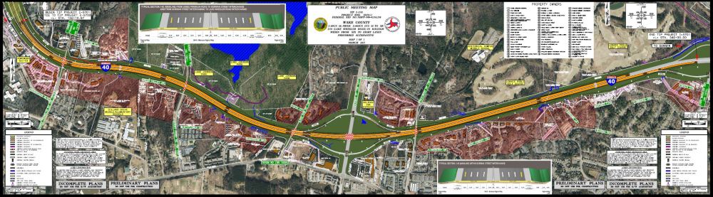
Study Area / Vicinity Map:
This map provides an outline of the area in which human and natural environmental studies are performed for the project. This map is provided for general reference information only.
__________________________________________________________________________________________________________________________________
Project Overview Video
Project No. I-5701
Addition of Lane on I-40/440 between the I-40/I-440/U.S. 1/U.S 64 interchange and Lake Wheeler Road.
Clicking on the link or the map will open the map in a new window for viewing or download.
I-5701 Typical Sections
The Preferred Alternative will create one new through lane in each direction by connecting the existing auxiliary lanes along the project. The project will then create a new auxiliary lane in each direction to replace the ones converted to through lanes.
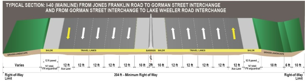
Due to the bridge width, auxiliary lanes will not be added at the Gorman Street interchange. There will be four through-lanes at this location upon completion of the project.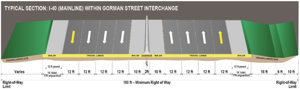
____________________________________________________________________________________________________________________________
Project No. I-5703
Interchange improvements at I-40/440/U.S. 1/64 area
At the 2019 public meeting 3 alternatives were presented.
Due to design/signage constraints, Alternative 1 was removed from consideration.
Maps of Alternatives
Alternative 1 - (As previously presented)
A traffic signing plan for Alternative 1 could not be designed to meet the standards in the Manual of Uniform Traffic Control Devices. There is not enough space in some locations to place signs at the proper distances from exits.
Therefore, the Federal Highway Administration would not approve funds for this alternative.
A modified design for Alternative 1 that would meet the standards would require replacing the Walnut Street bridge over U.S. 1/U.S. 64 and the Crossroads Flyover bridge over U.S. 1/U.S. 64, incurring substantial increased costs and disruption to traffic patterns during construction.
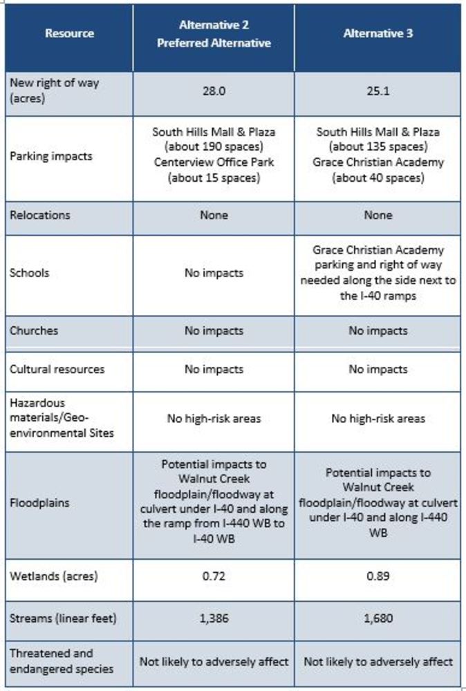
Alternative 2 - Preferred Alternative
Alternative 2 is NCDOT’s preferred alternative. It includes flyovers for the two heaviest traffic movements, which are:
- northbound U.S. 1/U.S. 64 to westbound I-40
- westbound I-40 to southbound U.S. 1/U.S. 64
The loop ramp from northbound U.S. 1/ U.S. 64 to westbound I-40 shown on the map as Loop A would be removed.
Alternative 3 - (As previously presented)
Alternative 3 is similar to Alternative 2, but it includes a third flyover ramp to carry traffic from Raleigh westbound on I-440 to eastbound I-40 toward Garner.
Two loop ramps would be removed:
- northbound U.S. 1/U.S. 64 to westbound I-40 shown on the map as Loop A
- westbound I-440 to eastbound I-40 shown on the map as Loop C
There are no back-to-back loop ramps in this alternative.
There are two design elements common to all alternatives:
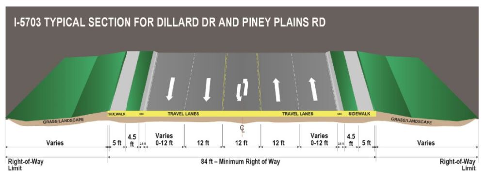
• The relocation of the northbound U.S. 1/U.S.64 Walnut Street entrance/exit ramps southward to connect to Dillard Drive/Piney Plains Road
• The elimination of the Crossroads slip ramp from the Crossroads Plaza Mall to northbound U.S. 1/U.S. 64.
These existing ramps are too close to the new designs of the main interchange to meet design standards for traffic operations.
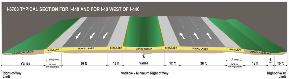
I-5703 Preferred Alternative Typical Sections
RESOURCES FOR PROPERTY OWNERS
Although the N.C. Department of Transportation works to minimize the number of homes and businesses displaced by a road project, it is inevitable, in many cases, that a certain amount of private property is needed. The following information explains right of way acquisition and answers questions about the process.
Right-of-Way Brochure Single Page Layout Folleto del Proceso de Adquisición de Bienes Raíces
Right-of-Way Frequently Asked Questions
Right of way Acquisition Process Videos
Documents
Open House Public Meeting held:
March 14, 2023 4-7 P.M.
Hope Community Church (Atrium)
821 Buck Jones Road
Raleigh
Project No. I-5701
Impacts
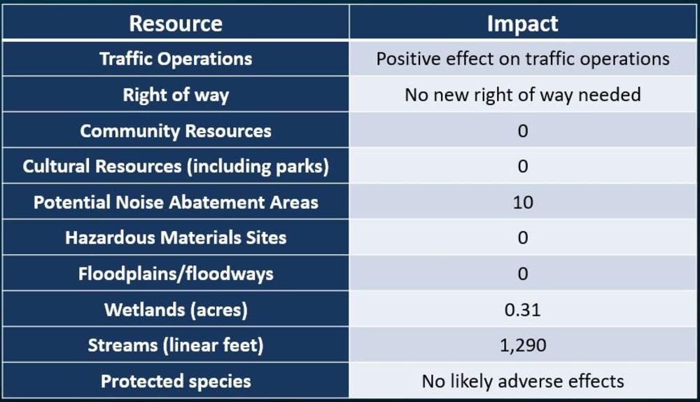
I-5701
Estimated Costs
Activity | Preferred Alternative |
|---|---|
Right of Way Acquisition | No new Right of Way needed |
| Utilities | $ 3.4 Million |
| Construction | $91.6 Million |
| Total Cost | $95.0 Million |
I-5703
Impacts
Activity | Preferred Alt |
Right of Way Acquisition | $ 34.8 Million |
Utilities | $ 7.2 Million |
Construction | $ 152 Million |
Total Cost | $ 194 Million |
Questions or Comments
If you have questions or wish to provide comments to the project team, you may contact the team in any of the following ways by March 28, 2023:
Allison White
Senior Project Manager
NCDOT Project Management Unit
1545 Mail Service Center
Raleigh, NC 27699-1545
Email:
Phone:
984-205-6615 Project Code 4019
(please leave us a message)