 BR-0160: N.C. 179 (Beach Drive SW) Bridge - Brunswick
BR-0160: N.C. 179 (Beach Drive SW) Bridge - Brunswick
The N.C. Department of Transportation is proposing to replace the bridge on N.C. 179 Business (Beach Drive S.W.) over the Calabash River in Brunswick County.
The existing bridge was built in 1975 and is in need of replacement. The new bridge will provide a connection across the Calabash River with sufficient capacity to allow for emergency access, hurricane evacuation, and acceptable travel times. The new bridge will be higher and longer to account for increased coastal flooding.
Interactive Study Area Map
Waterfront Park - Federal Highway Administration (FHWA)
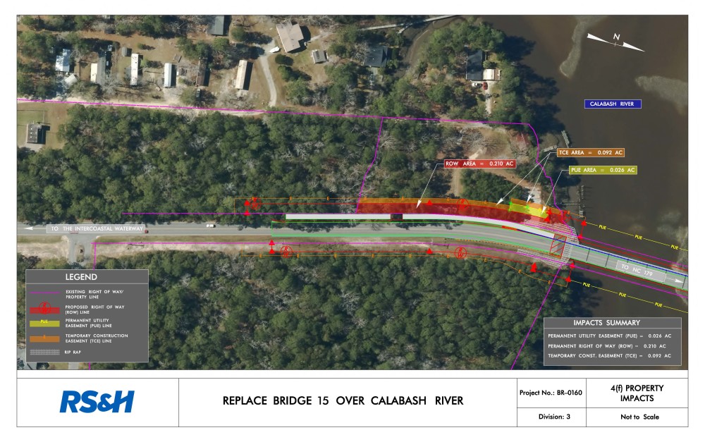
The Waterfront Park is a Town of Calabash public facility within the study area of the project. For Federally-funded projects such as BR-0160, public parks and recreation facilities are afforded special protection under Section 4(f) of the USDOT Act (recodified in 49 U.S.C. § 303 and 23 U.S.C. § 138), and Section 6009(a) of SAFETEA-LU (23 CFR 774). Provisions in SAFETEA-LU allow that if a proposed transportation project is determined to not “adversely affect the activities, features, and attributes” of the resource protected under Section 4(f), then a de minimis finding can be made by FHWA to satisfy the requirements of Section 4(f), which is their intent for this project.
The project’s effect on Town of Calabash land and the Waterfront Park are based on preliminary engineering design (plan sheets attached). Preliminary designs indicate that NCDOT would require approximately 0.210 acres of right-of-way (ROW), 0.026 acres of public utility easement, and 0.092 acres of temporary construction easement (TCE) from Waterfront Park. Although the project will require the use of land from the park, access will be maintained to Waterfront Park for users once construction is completed. In addition, the project will provide a 10-foot wide multi-use path along the west side of N.C. 179B (Beach Drive SW) that will connect to the Waterfront Park and provide additional access.
Download PDF of the 4(f) Property Impact Map
Project Comments
Due to Covid-19, NCDOT has suspended in-person meetings until further notice.
NCDOT accepts comments throughout all phases of project development.
The public is encouraged to leave comments using this website, email, or phone number.
Email: CalabashRiver-Bridge@publicinput.com
Phone Number: 984-205-6615 enter project code 5446
Project Design
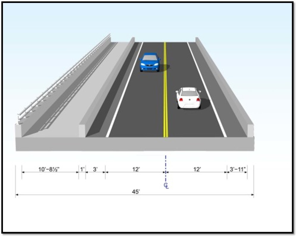
The proposed bridge will:
Be approximately 576 feet long
Provide two 12-foot lanes, one lane in each direction
Include a 4-foot paved shoulder on the northbound side of the roadway
Include a 10-foot wide multi-use path along the southbound side of the roadway, separated from the road by a 42 inch vertical concrete barrier
Detour Route
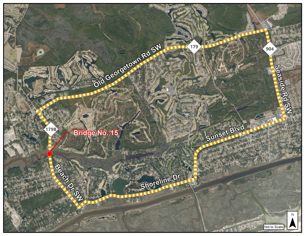
Construction is expected to have a minimal impact on the surrounding environment and will require an off-site detour during the 18 months of construction.
The detour route, illustrated below, will follow Old Georgetown Road SW, Seaside Road SW, Sunset Boulevard and Beach Drive SW.
Project Timeline
Milestone | Date* |
|---|---|
Project Newsletter | November 2021 |
Environmental Document | December 2021 |
Right-of -Way | January 2022 |
Construction | After Labor Day 2023 |
| Construction Vompletion | Spring 2025 |
* Future dates are preliminary and subject to change
Project Funding
| Cost* |
|---|---|
Project Development & Design | $ 4,3 million |
Construction | $16.4 million |
Total | $20.7 million |
Costs are preliminary and subject to change
Project Contact
Derek Pielech, PE
NCDOT Division 3
5501 Barbados Boulevard
Castle Hayne, NC 28429
CalabashRiver-Bridge@publicinput.com
984-205-6615 code 5446
RESOURCES FOR PROPERTY OWNERS
Although the N.C. Department of Transportation works to minimize the number of homes and businesses displaced by a road project, it is inevitable, in many cases, that a certain amount of private property is needed. The following information explains right of way acquisition and answers questions about the process.
Right-of-Way Brochure Single Page Layout Folleto del Proceso de Adquisición de Bienes Raíces
Right-of-Way Frequently Asked Questions
Right of way Acquisition Process Videos