 U-5766 Steele Creek Road Improvements
U-5766 Steele Creek Road Improvements
Preliminary Engineering Activities for this project
have resumed.
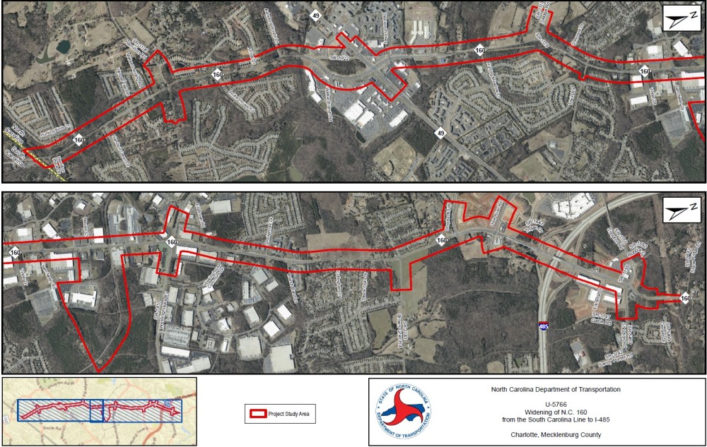
The North Carolina Department of Transportation proposes to widen N.C. 160 (Steele Creek Road) from the South Carolina Line to I-485 in Charlotte.
The purpose of the project is to:
alleviate existing congestion
improve travel conditions along N.C. 160 (Steele Creek Road) within the project limits
enhance bicycle and pedestrian accommodations
Vicinity and Study Area Map:
Project Overiew & Purpose
The purpose of the proposed project is to alleviate exisiting congestion and improve travel conditions along N.C. 160 (Steele Creek Road) within the project limits. The level of service (LOS) of a roadway is the measure of its traffic carrying ability. Levels of service range from A to F, "A" being the best scenario with unrestricted maneuverability and operating speeds, and "F" being the worst scenario where travel on a roadway is characterized by "stop and go" conditions. Six of the signalized intersections along the project operate at Level of Service (LOS) E or F during the AM or PM peak period. For the 2040 No-Build conditition, with no improvements along the corridor, congestion and delays are anticipated to increase in both peak periods.
Other desirable outcomes of the project are to improve travel conditions through the area and enhance bicycle and pedestrian accommodations.
Project Design Concept
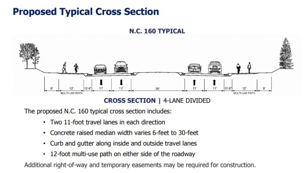
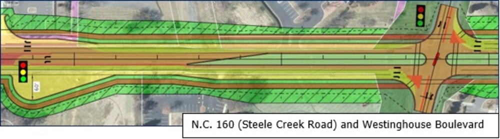
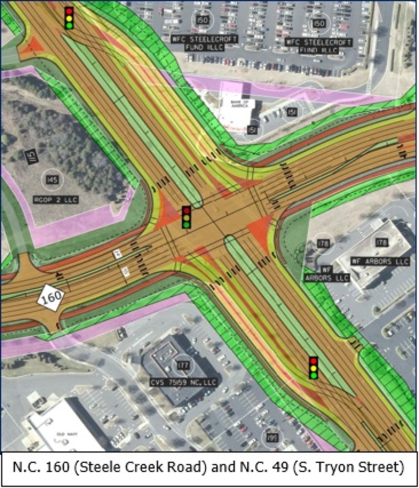
The project proposes to widen N.C. 160 from two lanes to a four-lane median divided roadway the length of the project. While several of the existing intersections will remain as traditional full movement intersections, NCDOT is studying various intersection treatments at the remaining intersections, including reduced conflict intersections and a continuous flow intersection at N.C. 160 and N.C. 49 (S. Tryon Street).
Traffic will be maintained within the existing corridor during construction.
The project design concept may be revised based on comments received from the public, local officials, and resource/regulatory agencies. The maps are subject to change due to the potential for design modifications during the planning process.
What is a Michigan Left Reduced Conflict Intersection (Michigan Left RCI)?
Where a Michigan Left is in place, left turns at the intersection, from either the main road or the side road, are not allowed. Instead, to turn left, drivers must go straight or turn right to enter the flow of traffic, then they pull into a dedicated lane to make a U-turn. There may be a traffic signal at this location.
Benefits of a Michigan Left RCI:
- Safety - typically reduces left-turn and angle-type crashes (the most severe types of crashes)
- Reduces congestion
- Improves traffic flow, allowing residents and other customers easier access to businesses
- Improves roadway operations
What is a Reduced Conflict Intersection (RCI)?
With the most common type of RCI, drivers on the main road follow their usual paths, but raised medians redirect drivers from the side road. When there is a safe opening in traffic, drivers turn right to enter the flow of traffic on the main route. To go the other direction, or cross the highway, they pull into a dedicated lane, typically less than 1,000 feet away, to make a U‑turn. There may be a traffic signal at this location. Improved traffic flow is possible by simplifying traffic signal phasing and allowing both directions of traffic to move simultaneously.
Benefits of an RCI:
- Simplifies how traffic is moved through the area, making travel safer and quicker
- Improves safety for motorists and pedestrians, by limiting the number of conflict points
- Accommodates more traffic volume without increased delays
- Allows for the City or NCDOT to adjust the timing of the traffic signals to control the speed at which drivers move through the corridor
What is a Reverse Reduced Conflict Intersection (Reverse RCI)?
With a Reverse RCI, drivers on the main road will not be able to make a left-turn directly onto the side road. Instead, drivers will enter a dedicated lane to make a U-turn on the main road and then make a right-turn to continue onto the side road.
A Reverse RCI allows drivers to turn left from the side road directly onto the main road. A Reverse RCI is typically common at intersections when the side road experiences high left turn volumes which may overwhelm the U-turn.
Benefits of a Reverse RCI:
- Simplifies how traffic is moved through the area, making travel safer and quicker
- Removes most of the crossing conflicts, typically resulting in less severe crashes
What is a Continuous Flow Intersection (CFI)?
A continuous flow intersection (CFI) is an alternative intersection design to a traditional intersection. At a traditional intersection, left-turning traffic is located in the middle of the road, so oncoming through traffic must wait for vehicles to turn left. A continuous flow intersection shifts left-turning traffic to the outer section of the road, allowing left-turning and oncoming through traffic to move simultaneously.
A CFI can help alleviate congestion while increasing travel capacity by redirecting the flow of left-turning traffic and simplifying traffic signal phasing. Pedestrians and bicyclists can also safely navigate the intersection utilizing the designated crosswalks.
Benefits of a CFI:
- Improves mobility and safety by allowing vehicles to move more efficiently through an intersection
- Alleviates congestion while increasing travel capacity
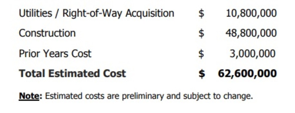
Estimated Project Cost
This project is listed as Project U-5766 in the N.C. Department of Transportation’s State Transportation Improvement Program and is funded for $62.6 million.
Tentative Project Schedule
Project U-5766 is shown in the N.C. Department of Transportation’s State Transportation Improvement Program. The current milestone dates are shown below.

Public Involvement
Public involvement is an integral part of the planning process.
NCDOT encourages citizen involvement on transportation projects, and will consider your suggestions and address your concerns,
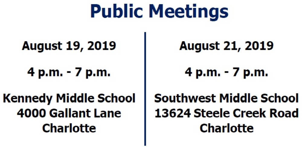
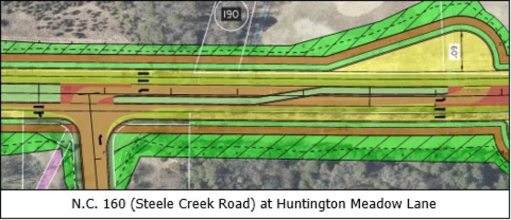
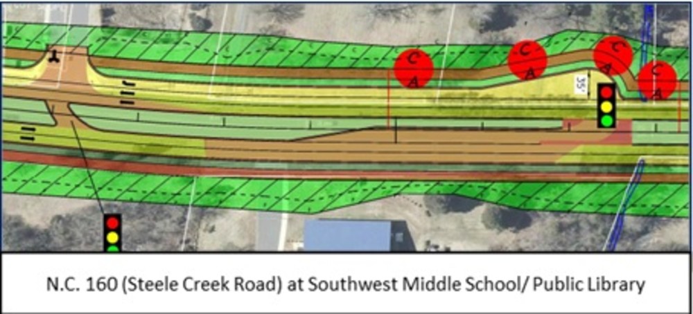
Maps presented at both the August 19th and August 21st Public Meetings
Map 1: South Carolina Line to North of Hamilton Road
Map 2: North of Hamilton Road to N.C. 49
Map 2a: N.C. 49 and N.C. 160 Intersection
Map 3: N.C. 49 to North of Sledge Road
Map 4: North of Sledge Road to NS Railroad
Map 5: NS Railroad to North of Steele Meadow Road
Comments/Questions
Comments may be submitted below, via phone, email (SteeleCreek-Widening@publicinput.com), or U.S. Mail to the Project Manager listed below, or at any meeting.
All comments received carry equal weight, regardless of submission method.
All comments will be reviewed and suggestions/recommendations
incorporated into designs where feasible.
PROJECT CONTACT INFORMATION
Brian Query, P.E.
Project Manager
NCDOT Highway Division 10
12033 East Independence Blvd, Suite H
Matthews, NC 28105
980-262-6294
RESOURCES FOR PROPERTY OWNERS
Although the N.C. Department of Transportation works to minimize the number of homes and businesses displaced by a road project, it is inevitable, in many cases, that a certain amount of private property is needed. The following information explains right of way acquisition and answers questions about the process.
Right-of-Way Brochure Single Page Layout Folleto del Proceso de Adquisición de Bienes Raíces
Right-of-Way Frequently Asked Questions
Right of way Acquisition Process Videos